News Detail
Satellite pictures reveal the condition of lakes
October 4, 2018 |
Hardly any other ecosystem is more strongly affected by environmental changes than fresh-water lakes. This makes it essential to monitor their condition. But: taking routine probes of every lake is costly, and few countries can do it or consider it a priority.
One solution to this dilemma is the use of earth-surveying satellites: Equipped with sensors, these satellites fly over every part of the earth at regular intervals, providing a plethora of data with which scientists can keep track of sea level, ocean temperature or the extent of ice cover at the poles – or, indeed, the water quality in fresh-water lakes. This last is the central research concern of geographer Daniel Odermatt, who has been working at Eawag since this spring and who leads the new remote sensing group. Using data from the European Space Agency’s satellite Envisat, he has created maps of many water-quality parameters such as turbidity, temperature and algal bloom for more than 350 lakes all over the world – among them ten Swiss lakes. The maps are based on data gathered from 2002 to 2012.
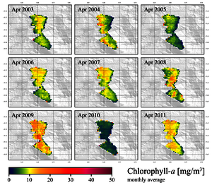
The diagram above shows the average chlorophyll concentration in Lake Zug in the month of April between 2003 and 2011. The information is taken from satellite pictures made by Envisat. The varying monthly averages stem above all from weather differences. (Diagram: Daniel Odermatt)
Recognizing climate change
“Given a cloudless view, a quiet lake surface and a widespread algal bloom, it is relatively simple to determine the water quality in a satellite picture,” says Odermatt. The difficulty lies much more in recognizing interpretable pixels in several hundred thousand-satellite pictures. He and his research colleagues thus tinkered for several years on algorithms that search for such pixels in the pictures and determine from their colour the quantity of algae, turbidity or quantity of blue algae. “Because the satellites deliver not only snapshots but also pictures taken at high resolution over a longer period, environmental changes can be more clearly recognized than with ordinary sampling,” adds Odermatt.
As of 2012, the satellite Envisat is no longer sending out pictures, as communication with the earth station ceased suddenly for unknown reasons. But since 2015 several follow-on satellites orbit the earth, and these shoot pictures even more often and with higher resolution than Envisat. Thanks to this constant satellite monitoring, it will be possible in the future to get information about the condition of lakes all over the world in real time.
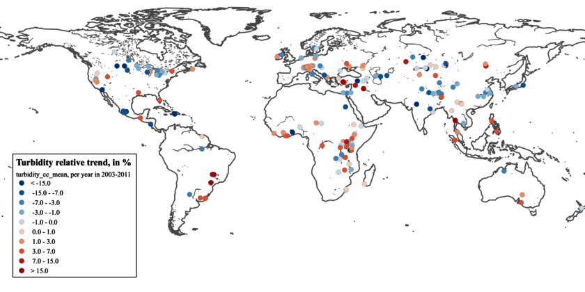
The map shows the average over nine years of annual changes in the turbidity of the lakes analysed. The greatest changes occur in lakes with greatly decreased or increased volume.
(Illustration: Odermatt et al., 2018)


