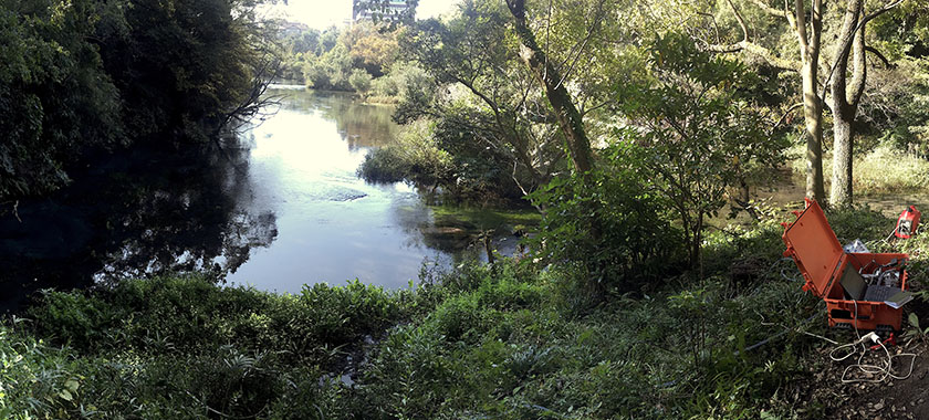
Tracer measurements at the origin of Kakitagawa, the largest spring-fed river at the foot of Mt Fuji in Japan.
In the Tracer Hydrogeology group, our goal is to improve the conceptual and quantitative understanding of interactions between groundwater, surface waters, and groundwater-dependent ecosystems. We build on two fundamental pillars of modern hydrogeological research: (a) various measurements and observations of hydrological and biogeochemical tracers, and (b) the modeling of hydrogeological processes using fully coupled hydrological models (so-called Integrated Surface-Subsurface Hydrological Models, or ISSHM).
We are currently focusing on the development and application of novel hydrological tracer methods and on improving our understanding of groundwater–surface water systems through the explicit integration of tracer data into modeling. The tracer methods we currently develop and apply include both field-based continuous measurements and laboratory-based analyses of:
(a) dissolved gases, e.g., through GE-MIMS-supported analysis of N₂, O₂, CO₂, CH₄, and noble gases, or the measurement of He, Ar, Kr, and Xe isotopes in the noble gas laboratory at ETH Zurich; (b) naturally occurring radioactive tracers, e.g., 222Rn, 37Ar, 39Ar, 85Kr, 14C, 3H, and 3H/3He; (c) microbial information, e.g., through flow cytometric measurement of total cell counts, LNA and HNA bacteria, and microbial fingerprints, or through sequencing of microbial environmental DNA (eDNA) (16S rRNA amplicon sequencing and whole-genome metagenomic analyses).
array(5 items)0 => Snowflake\Publications\Domain\Model\Publicationprototypepersistent entity (uid=36450, pid=124)originalId => protected36450 (integer)
authors => protected'van Rooyen, J.; Vennemann, T.; Purtschert, R.; Affolter Kast, A.; Brennwald, M. S.; Kipfer, R.; Schilling, O.&nb sp;S.' (157 chars)
title => protected'Anthropogenic tritium as a continental-scale tracer in river-derived recharg e' (77 chars)
journal => protected'Nature Water' (12 chars)
year => protected2026 (integer)
volume => protected4 (integer)
issue => protected'' (0 chars)
startpage => protected'444' (3 chars)
otherpage => protected'454' (3 chars)
categories => protected'' (0 chars)
description => protected'Groundwater, enhanced through managed aquifer recharge (MAR), plays a centra l role in mitigating current and future water stress. Here we evaluate anthr opogenic and natural water isotopes as tracers of groundwater flow dynamics within alluvial MAR systems. High-resolution sampling (daily/weekly) of stab le isotopes (δ<sup>18</sup>O and δ<sup>2</sup>H) and tritium (<sup>3</sup> H), influenced by nuclear power plant effluents, is used to trace and quanti fy the movement of infiltrated river water through an alluvial aquifer along the Rhine River in Switzerland. Time-series deconvolution is applied to qua ntify the tracer-based travel time distribution and to predict travel times throughout the entire MAR scheme. The results demonstrate the suitability of <sup>3</sup>H as a quasi-conservative travel time tracer in systems where t he infiltrating river water is marked by nuclear power plant discharges—a situation prevalent along the banks of many large river basins globally. Deu terium excess proved equally effective as a bulk travel time tracer, reflect ing distinct seasonal meltwater signals expected in major European rivers. T hese findings quantify MAR recovery rates and wellhead protection zones, sup porting sustainable groundwater management under natural and anthropogenic p ressures.' (1301 chars)
serialnumber => protected'' (0 chars)
doi => protected'10.1038/s44221-026-00616-x' (26 chars)
uid => protected36450 (integer)
_localizedUid => protected36450 (integer)modified_languageUid => protectedNULL
_versionedUid => protected36450 (integer)modifiedpid => protected124 (integer)1 => Snowflake\Publications\Domain\Model\Publicationprototypepersistent entity (uid=36244, pid=124)originalId => protected36244 (integer)
authors => protected'Musy, S. L.; Dresmann, H.; Tomonaga, Y.; Sano, Y.; Schilling, O. S.' (102 chars)
title => protected'Modeling a geologically complex volcanic watershed for integrated water res ources management in Mt. Fuji, Japan' (112 chars)
journal => protected'Scientific Data' (15 chars)
year => protected2026 (integer)
volume => protected13 (integer)
issue => protected'1' (1 chars)
startpage => protected'69 (21 pp.)' (11 chars)
otherpage => protected'' (0 chars)
categories => protected'' (0 chars)
description => protected'This dataset provides high-resolution 3D geological and integrated hydrologi cal models of Mt. Fuji watershed in Japan. The watershed’s complex volcani c and tectonic setting, large spatial extent, and limited subsurface data pr esent significant challenges for integrated hydrological modeling. Diverse g eological datasets – borehole logs, geological maps, and hydrofacies sur faces – were collected, processed, and used to construct and validate a 3D geological model suitable for integrated hydrological simulations. Buildi ng on this, a 3D numerical model for integrated hydrological simulations was constructed. The repository includes 3D hydrofacies surfaces in raster form at, numerical mesh files, and input configurations necessary to run simulati ons with the integrated surface-subsurface hydrological simulator HydroGeoSp here. The preparation of heterogeneous geological data, construction of hydr ofacies surfaces, generation of the numerical mesh, and setup of the integr ated hydrological model are described in a streamlined, reproducible workflo w suited for volcanic contexts and transferable to other geologically comple x or data-limited regions. These resources are intended to reduce trial-and- error iterations and support further research in groundwater assessment, mod el calibration, climate impact studies, and hazard mitigation.' (1354 chars)
serialnumber => protected'' (0 chars)
doi => protected'10.1038/s41597-025-06380-z' (26 chars)
uid => protected36244 (integer)
_localizedUid => protected36244 (integer)modified_languageUid => protectedNULL
_versionedUid => protected36244 (integer)modifiedpid => protected124 (integer)2 => Snowflake\Publications\Domain\Model\Publicationprototypepersistent entity (uid=35763, pid=124)originalId => protected35763 (integer)
authors => protected'Råman Vinnå, L.; Bigler, V.; Schilling, O. S.; Epting, J.' (84 chars)
title => protected'Multi-fidelity model assessment of climate change impacts on river water tem peratures and thermal extremes and potential effects on cold-water fish in S witzerland' (162 chars)
journal => protected'Hydrology and Earth System Sciences' (35 chars)
year => protected2025 (integer)
volume => protected29 (integer)
issue => protected'21' (2 chars)
startpage => protected'5931' (4 chars)
otherpage => protected'5953' (4 chars)
categories => protected'' (0 chars)
description => protected'River water temperature is a key factor for water quality, aquatic life, and human use. Under climate change, inland water temperatures have increased a nd are expected to do so further, increasing the pressure on aquatic life an d reducing the potential for human use. Here, future river water temperature s are projected for Switzerland based on a multi-fidelity modelling approach . We use 2 different, semi-empirical surface water temperature models, 22 co upled and downscaled general circulation- to regional climate models, future projections of river discharge from 4 hydrological models and 3 climate cha nge scenarios (RCP2.6, 4.5, and 8.5). By grouping stream sections, catchment s and spring-fed water courses under representative thermal regimes, and by employing hierarchical cluster-based thermal pattern recognition, an optimal model and model configuration was selected, model performance optimized and climate change impact assessment on river water temperatures improved.<br / >Results show that, until the end of the 21<sup>st</sup> century, average ri ver water temperatures in Switzerland will likely increase by 3.1±0.7 °C ( or 0.36±0.1 °C per decade) under RCP8.5, while under RCP2.6 the temperatur e increase may remain at 0.9±0.3 °C (0.12±0.1 °C per decade). Under RCP8 .5, temperatures of rivers classified as being in the Alpine thermal regime will increase the most, that is, by 3.5±0.5 °C, followed by rivers of the Downstream Lake regime, 3.4±0.5 °C.<br />A general decrease of river disch arge in summer (-10 to -40 %) and increase in winter (+10 to +30 %), combine d with a further increase in average near-surface air temperatures (0.5 °C per decade), bears the potential to not only result in overall warmer rivers , but also in prolonged periods of extreme summer river water temperatures. This dramatically increases the thermal stress potential for temperature sen sitive aquatic species such as the brown trout in rivers where such periods occur already, but also ...' (2181 chars)
serialnumber => protected'1027-5606' (9 chars)
doi => protected'10.5194/hess-29-5931-2025' (25 chars)
uid => protected35763 (integer)
_localizedUid => protected35763 (integer)modified_languageUid => protectedNULL
_versionedUid => protected35763 (integer)modifiedpid => protected124 (integer)3 => Snowflake\Publications\Domain\Model\Publicationprototypepersistent entity (uid=33532, pid=124)originalId => protected33532 (integer)
authors => protected'van Tiel, M.; Aubry-Wake, C.; Somers, L.; Andermann, C.; Avanzi, F.; Baraer, M.; Chiogna, G.; Daigre, C.; Das,&n bsp;S.; Drenkhan, F.; Farinotti, D.; Fyffe, C. L.; de Gr aaf, I.; Hanus, S.; Immerzeel, W.; Koch, F.; McKenzie,&n bsp;J. M.; Müller, T.; Popp, A. L.; Saidaliyeva, Z .; Schaefli, B.; Schilling, O. S.; Teagai, K.; Thornton, J. M.; Yapiyev, V.' (490 chars)
title => protected'Cryosphere–groundwater connectivity is a missing link in the mountain wate r cycle' (83 chars)
journal => protected'Nature Water' (12 chars)
year => protected2024 (integer)
volume => protected2 (integer)
issue => protected'7' (1 chars)
startpage => protected'624' (3 chars)
otherpage => protected'637' (3 chars)
categories => protected'' (0 chars)
description => protected'The mountain cryosphere and groundwater play pivotal roles in shaping the hy drological cycle, yet their connectivity remains incompletely understood. Cu rrent knowledge on meltwater recharge and consequent groundwater discharge p rocesses is better developed for snow–groundwater connectivity than for gl acier–groundwater connectivity. Estimates of meltwater recharge vary consi derably, which is probably a function of not only inherent catchment charact eristics but also of the different spatio-temporal scales involved and the u ncertainties in the methods used. This hinders a comprehensive understanding of the mountain water cycle. As glaciers retreat, permafrost thaws and snow pack diminishes, the relative importance of mountain groundwater is expected to increase. However, shifting and declining recharge from the cryosphere m ay decrease absolute groundwater amounts and fluxes with as-yet unknown effe cts on catchment-scale hydrological processes. We therefore stress the need to better quantify mountain cryosphere–groundwater connectivity to predict climate change impacts on mountain water supply and to support sustainable water resource management of downstream socio-ecological systems.' (1205 chars)
serialnumber => protected'' (0 chars)
doi => protected'10.1038/s44221-024-00277-8' (26 chars)
uid => protected33532 (integer)
_localizedUid => protected33532 (integer)modified_languageUid => protectedNULL
_versionedUid => protected33532 (integer)modifiedpid => protected124 (integer)4 => Snowflake\Publications\Domain\Model\Publicationprototypepersistent entity (uid=30027, pid=124)originalId => protected30027 (integer)
authors => protected'Schilling, O. S.; Nagaosa, K.; Schilling, T. U.; Br ennwald, M. S.; Sohrin, R.; Tomonaga, Y.; Brunner, P.; Kipfer, R.; Kato, K.' (186 chars)
title => protected'Revisiting Mt Fuji’s groundwater origins with helium, vanadium and environ mental DNA tracers' (94 chars)
journal => protected'Nature Water' (12 chars)
year => protected2023 (integer)
volume => protected1 (integer)
issue => protected'' (0 chars)
startpage => protected'60' (2 chars)
otherpage => protected'73' (2 chars)
categories => protected'' (0 chars)
description => protected'Known locally as the water mountain, for millennia Japan’s iconic Mt Fuji has provided safe drinking water to millions of people via a vast network of groundwater and freshwater springs. Groundwater, which is recharged at high elevations, flows down Fuji’s flanks within three basaltic aquifers, ulti mately forming countless pristine freshwater springs among Fuji’s foothill s. Here we challenge the current conceptual model of Fuji being a simple sys tem of laminar groundwater flow with little to no vertical exchange between its three aquifers. This model contrasts strongly with Fuji’s extreme tect onic instability due to its unique location on top of the only known contine ntal trench–trench–trench triple junction, its complex geology and its u nusual microbial spring water communities. On the basis of a unique combinat ion of microbial environmental DNA, vanadium and helium tracers, we provide evidence for prevailing deep circulation and a previously unknown deep groun dwater contribution to Fuji’s freshwater springs. The most substantial dee p groundwater upwelling has been found along Japan’s most tectonically act ive region, the Fujikawa-kako Fault Zone. Our findings broaden the hydrogeol ogical understanding of Fuji and demonstrate the vast potential of combining environmental DNA, on-site noble gas and trace element analyses for groundw ater science.' (1381 chars)
serialnumber => protected'' (0 chars)
doi => protected'10.1038/s44221-022-00001-4' (26 chars)
uid => protected30027 (integer)
_localizedUid => protected30027 (integer)modified_languageUid => protectedNULL
_versionedUid => protected30027 (integer)modifiedpid => protected124 (integer)
Anthropogenic tritium as a continental-scale tracer in river-derived recharge
Groundwater, enhanced through managed aquifer recharge (MAR), plays a central role in mitigating current and future water stress. Here we evaluate anthropogenic and natural water isotopes as tracers of groundwater flow dynamics within alluvial MAR systems. High-resolution sampling (daily/weekly) of stable isotopes (δ18O and δ2H) and tritium (3H), influenced by nuclear power plant effluents, is used to trace and quantify the movement of infiltrated river water through an alluvial aquifer along the Rhine River in Switzerland. Time-series deconvolution is applied to quantify the tracer-based travel time distribution and to predict travel times throughout the entire MAR scheme. The results demonstrate the suitability of 3H as a quasi-conservative travel time tracer in systems where the infiltrating river water is marked by nuclear power plant discharges—a situation prevalent along the banks of many large river basins globally. Deuterium excess proved equally effective as a bulk travel time tracer, reflecting distinct seasonal meltwater signals expected in major European rivers. These findings quantify MAR recovery rates and wellhead protection zones, supporting sustainable groundwater management under natural and anthropogenic pressures.
van Rooyen, J.; Vennemann, T.; Purtschert, R.; Affolter Kast, A.; Brennwald, M. S.; Kipfer, R.; Schilling, O. S. (2026) Anthropogenic tritium as a continental-scale tracer in river-derived recharge, Nature Water, 4, 444-454, doi:10.1038/s44221-026-00616-x, Institutional Repository
Modeling a geologically complex volcanic watershed for integrated water resources management in Mt. Fuji, Japan
This dataset provides high-resolution 3D geological and integrated hydrological models of Mt. Fuji watershed in Japan. The watershed’s complex volcanic and tectonic setting, large spatial extent, and limited subsurface data present significant challenges for integrated hydrological modeling. Diverse geological datasets – borehole logs, geological maps, and hydrofacies surfaces – were collected, processed, and used to construct and validate a 3D geological model suitable for integrated hydrological simulations. Building on this, a 3D numerical model for integrated hydrological simulations was constructed. The repository includes 3D hydrofacies surfaces in raster format, numerical mesh files, and input configurations necessary to run simulations with the integrated surface-subsurface hydrological simulator HydroGeoSphere. The preparation of heterogeneous geological data, construction of hydrofacies surfaces, generation of the numerical mesh, and setup of the integrated hydrological model are described in a streamlined, reproducible workflow suited for volcanic contexts and transferable to other geologically complex or data-limited regions. These resources are intended to reduce trial-and-error iterations and support further research in groundwater assessment, model calibration, climate impact studies, and hazard mitigation.
Musy, S. L.; Dresmann, H.; Tomonaga, Y.; Sano, Y.; Schilling, O. S. (2026) Modeling a geologically complex volcanic watershed for integrated water resources management in Mt. Fuji, Japan, Scientific Data, 13(1), 69 (21 pp.), doi:10.1038/s41597-025-06380-z, Institutional Repository
Multi-fidelity model assessment of climate change impacts on river water temperatures and thermal extremes and potential effects on cold-water fish in Switzerland
River water temperature is a key factor for water quality, aquatic life, and human use. Under climate change, inland water temperatures have increased and are expected to do so further, increasing the pressure on aquatic life and reducing the potential for human use. Here, future river water temperatures are projected for Switzerland based on a multi-fidelity modelling approach. We use 2 different, semi-empirical surface water temperature models, 22 coupled and downscaled general circulation- to regional climate models, future projections of river discharge from 4 hydrological models and 3 climate change scenarios (RCP2.6, 4.5, and 8.5). By grouping stream sections, catchments and spring-fed water courses under representative thermal regimes, and by employing hierarchical cluster-based thermal pattern recognition, an optimal model and model configuration was selected, model performance optimized and climate change impact assessment on river water temperatures improved. Results show that, until the end of the 21st century, average river water temperatures in Switzerland will likely increase by 3.1±0.7 °C (or 0.36±0.1 °C per decade) under RCP8.5, while under RCP2.6 the temperature increase may remain at 0.9±0.3 °C (0.12±0.1 °C per decade). Under RCP8.5, temperatures of rivers classified as being in the Alpine thermal regime will increase the most, that is, by 3.5±0.5 °C, followed by rivers of the Downstream Lake regime, 3.4±0.5 °C. A general decrease of river discharge in summer (-10 to -40 %) and increase in winter (+10 to +30 %), combined with a further increase in average near-surface air temperatures (0.5 °C per decade), bears the potential to not only result in overall warmer rivers, but also in prolonged periods of extreme summer river water temperatures. This dramatically increases the thermal stress potential for temperature sensitive aquatic species such as the brown trout in rivers where such periods occur already, but also rivers in where this previously was not a problem. By providing information of future water temperatures, the results of this study can guide managements climate mitigation efforts.
Råman Vinnå, L.; Bigler, V.; Schilling, O. S.; Epting, J. (2025) Multi-fidelity model assessment of climate change impacts on river water temperatures and thermal extremes and potential effects on cold-water fish in Switzerland, Hydrology and Earth System Sciences, 29(21), 5931-5953, doi:10.5194/hess-29-5931-2025, Institutional Repository
Cryosphere–groundwater connectivity is a missing link in the mountain water cycle
The mountain cryosphere and groundwater play pivotal roles in shaping the hydrological cycle, yet their connectivity remains incompletely understood. Current knowledge on meltwater recharge and consequent groundwater discharge processes is better developed for snow–groundwater connectivity than for glacier–groundwater connectivity. Estimates of meltwater recharge vary considerably, which is probably a function of not only inherent catchment characteristics but also of the different spatio-temporal scales involved and the uncertainties in the methods used. This hinders a comprehensive understanding of the mountain water cycle. As glaciers retreat, permafrost thaws and snowpack diminishes, the relative importance of mountain groundwater is expected to increase. However, shifting and declining recharge from the cryosphere may decrease absolute groundwater amounts and fluxes with as-yet unknown effects on catchment-scale hydrological processes. We therefore stress the need to better quantify mountain cryosphere–groundwater connectivity to predict climate change impacts on mountain water supply and to support sustainable water resource management of downstream socio-ecological systems.
van Tiel, M.; Aubry-Wake, C.; Somers, L.; Andermann, C.; Avanzi, F.; Baraer, M.; Chiogna, G.; Daigre, C.; Das, S.; Drenkhan, F.; Farinotti, D.; Fyffe, C. L.; de Graaf, I.; Hanus, S.; Immerzeel, W.; Koch, F.; McKenzie, J. M.; Müller, T.; Popp, A. L.; Saidaliyeva, Z.; Schaefli, B.; Schilling, O. S.; Teagai, K.; Thornton, J. M.; Yapiyev, V. (2024) Cryosphere–groundwater connectivity is a missing link in the mountain water cycle, Nature Water, 2(7), 624-637, doi:10.1038/s44221-024-00277-8, Institutional Repository
Revisiting Mt Fuji’s groundwater origins with helium, vanadium and environmental DNA tracers
Known locally as the water mountain, for millennia Japan’s iconic Mt Fuji has provided safe drinking water to millions of people via a vast network of groundwater and freshwater springs. Groundwater, which is recharged at high elevations, flows down Fuji’s flanks within three basaltic aquifers, ultimately forming countless pristine freshwater springs among Fuji’s foothills. Here we challenge the current conceptual model of Fuji being a simple system of laminar groundwater flow with little to no vertical exchange between its three aquifers. This model contrasts strongly with Fuji’s extreme tectonic instability due to its unique location on top of the only known continental trench–trench–trench triple junction, its complex geology and its unusual microbial spring water communities. On the basis of a unique combination of microbial environmental DNA, vanadium and helium tracers, we provide evidence for prevailing deep circulation and a previously unknown deep groundwater contribution to Fuji’s freshwater springs. The most substantial deep groundwater upwelling has been found along Japan’s most tectonically active region, the Fujikawa-kako Fault Zone. Our findings broaden the hydrogeological understanding of Fuji and demonstrate the vast potential of combining environmental DNA, on-site noble gas and trace element analyses for groundwater science.
Schilling, O. S.; Nagaosa, K.; Schilling, T. U.; Brennwald, M. S.; Sohrin, R.; Tomonaga, Y.; Brunner, P.; Kipfer, R.; Kato, K. (2023) Revisiting Mt Fuji’s groundwater origins with helium, vanadium and environmental DNA tracers, Nature Water, 1, 60-73, doi:10.1038/s44221-022-00001-4, Institutional Repository
By taking into account the interactions between surface waters and groundwater in real time, we improve operational groundwater modeling for drinking water, energy and agriculture.