Detecting and eliminating pollutants on bodies of water
Pesticides, PFAS, heavy metals, medicinal products, microplastics: A large number of chemical substances are released into the environment and pollute watercourses, lakes and groundwater. Hazardous for both humans and nature. Eawag is investigating how pollutants affect aquatic organisms and is developing methods to better identify and reduce micropollutants.
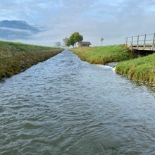
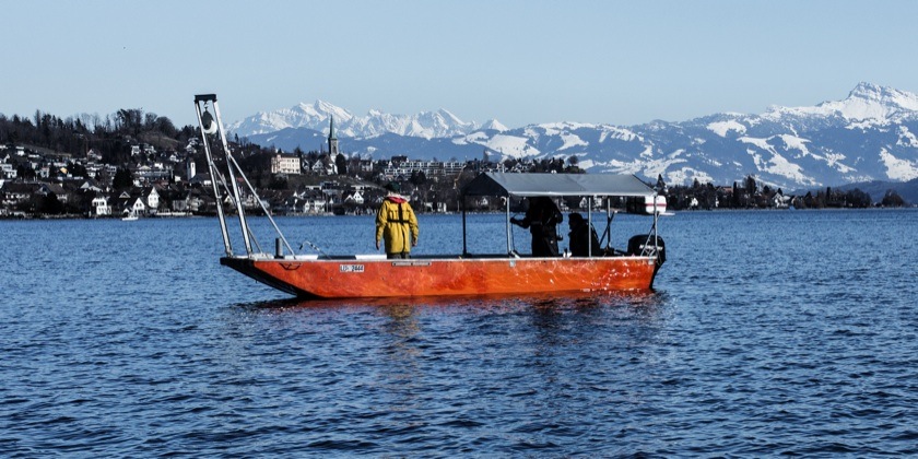
The researchers are investigating the water chemistry and biology in watercourses upstream and downstream of wastewater treatment plants (Photo: Eawag).
Toxic cocktail for fish and other creatures
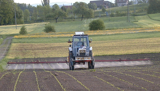
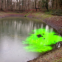
The majority of Swiss watercourses are polluted with micropollutants. Pesticides in particular and individual pharmaceutical products sometimes exceed the ecotoxicolpgical threshold limits. Various man-made substances can also be detected in groundwater and lakes. Many of them are toxic to aquatic organisms or impair their fertility. Eawag is investigating the impact of pollutants on aquatic organisms and how they affect aquatic ecosystems in Switzerland and other regions in the world.
Tracking down pollutants
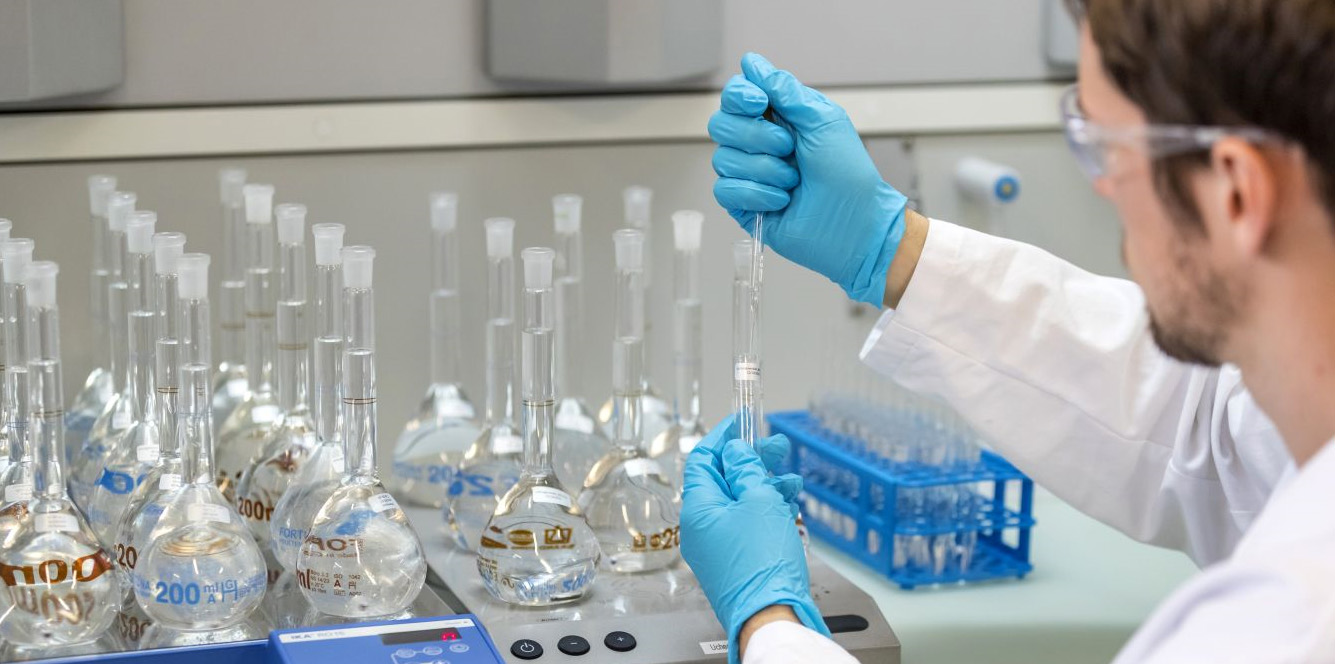
Not all micropollutants can be reliably detected with the measurement methods commonly used in practice. However, on order to be able to take effective measures for water protection, the concentration and the temporal fluctuations must be determined as accurately as possible. Eawag is therefore developing new measuring instruments and methods to detect the smallest contaminations of pollutants, discovered previously unknown substances and identify sources of contamination.
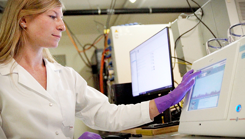
Christoph Ort (left) and Heinz Singer in the Ms2field trailer, an automated and mobile mass spectrometer that continuously measures water quality (Photo: Eawag, Aldo Todaro).
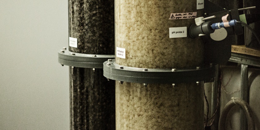
In its testing hall, Eawag is investigating how rain events affect the purification performance of filters with granulated activated carbon (Photo: Eawag, Alessandro Della Bella).
Reducing micropollutants in wastewater
Some of the pollutants enter bodies of water via wastewater from industry and households. Although the wastewater treatments plants in Switzerland are of a high standard, they are unable to adequately filter out many chemicals or some even not all. Eawag is working on the development of new technologies with which these pollutants can be removed from wastewater in the future,
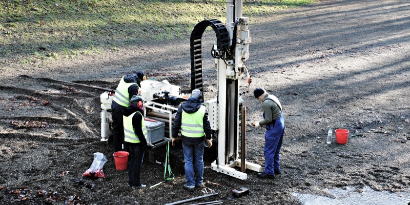
In the canton of Basel-Landschaft, existing pollution situation and hazards to groundwater were determined. The model area Hardwald is characterized by strongly urban and industrially areas.
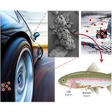
Tire and road wear particles (TRWP) are generated by the erosion of tires while driving, and represent a large part of anthropogenic particles released into the environment.
A large number and variety of chemicals used in households, healthcare, industry or agriculture enter our wastewater treatment plants with the domestic and industrial wastewater....
The Centre for Applied Ecotoxicology in Switzerland aims to identify and assess the effects of chemicals on our environment and to develop strategies to minimise risks.
array(3 items)0 => Snowflake\Publications\Domain\Model\Publicationprototypepersistent entity (uid=34990, pid=124)originalId => protected34990 (integer)
authors => protected'Monclús, L.; Arp, H. P. H.; Groh, K. J.; Falt ynkova, A.; Løseth, M. E.; Muncke, J.; Wang, Z.; W olf, R.; Zimmermann, L.; Wagner, M.' (202 chars)
title => protected'Mapping the chemical complexity of plastics' (43 chars)
journal => protected'Nature' (6 chars)
year => protected2025 (integer)
volume => protected643 (integer)
issue => protected'8071' (4 chars)
startpage => protected'349' (3 chars)
otherpage => protected'355' (3 chars)
categories => protected'' (0 chars)
description => protected'Plastic pollution is a pervasive and growing global problem. Chemicals in pl astics are often not sufficiently considered in the overall strategy to prev ent and mitigate the impacts of plastics on human health, the environment an d circular economy. Here we present an inventory of 16,325 known plastic che micals with a focus on their properties, presence in plastic and hazards. We find that diverse chemical structures serve a small set of functions, inclu ding 5,776 additives, 3,498 processing aids, 1,975 starting substances and 1 ,788 non-intentionally added substances. Using a hazard-based approach, we i dentify more than 4,200 chemicals of concern, which are persistent, bioaccum ulative, mobile or toxic. We also determine 15 priority groups of chemicals, for which more than 40% of their members are of concern. Finally, we examin e data gaps regarding the basic properties, hazards, uses and exposure poten tial of plastic chemicals. Our work maps the chemical landscape of plastics and contributes to setting the baseline for a transition towards safer and m ore sustainable materials and products. We propose that removing known chemi cals of concern, disclosing the chemical composition and simplifying the for mulation of plastics can provide pathways towards this goal.' (1276 chars)
serialnumber => protected'0028-0836' (9 chars)
doi => protected'10.1038/s41586-025-09184-8' (26 chars)
uid => protected34990 (integer)
_localizedUid => protected34990 (integer)modified_languageUid => protectedNULL
_versionedUid => protected34990 (integer)modifiedpid => protected124 (integer)1 => Snowflake\Publications\Domain\Model\Publicationprototypepersistent entity (uid=34150, pid=124)originalId => protected34150 (integer)
authors => protected'Furrer, V.; Junghans, M.; Singer, H.; Ort, C.' (65 chars)
title => protected'Realistic exposure scenarios in combined sewer overflows: how temporal resol ution and selection of micropollutants impact risk assessment' (137 chars)
journal => protected'Water Research' (14 chars)
year => protected2025 (integer)
volume => protected278 (integer)
issue => protected'' (0 chars)
startpage => protected'123318 (9 pp.)' (14 chars)
otherpage => protected'' (0 chars)
categories => protected'chemical risk assessment; acute ecotoxicity; temporal dynamics; urban draina ge; aquatic ecosystems; real exposure scenarios' (123 chars)
description => protected'Organic micropollutants in combined sewer overflows (CSOs) pose a potential risk to aquatic ecosystems. Previous studies mainly reported event mean conc entrations (EMCs) and often focused on a small number of substances. This st udy presents realistic exposure scenarios using high-temporal resolution (10 -minute) data from 24 events at two CSO sites. We analyzed 49 dissolved orga nic micropollutants for all events and 198 for four events, including pharma ceuticals, pesticides, and road-related compounds, of which we detected 83 s ubstances at least once. From these, we assessed the mixed chemical risk by applying acute quality criteria and evaluated how the risk assessment outcom e changes for two aspects: temporal resolution and selection of substances. Our results reveal that total risk quotients (RQ<sub>tot</sub>) can vary gre atly within CSO events, with 10-minute data capturing peak concentrations th at are missed with EMCs. Using EMCs underestimates the maximum RQ<sub>tot</s ub> of an event by a median factor of 4.9, up to a maximum factor of 6.9. Wh en comparing a selection of 20 substances from the Swiss Waters Protection O rdinance to a broader list of 49 substances commonly detected at CSOs and a comprehensive list of 198 substances, the estimated RQ<sub>tot</sub> increas es between 1.1 to 2.3-fold. RQ<sub>tot</sub> values exceed the threshold of 1 in 75 % of the events, requiring further dilution in the receiving water b ody. All three pollutant classes (pharma, pesticide, road) drive the total r isk, and no specific phase during overflow events consistently poses higher risk than other phases, which challenges the design of effective mitigation measures. Furthermore, the exposure scenarios presented here offer essential input for future ecotoxicological research as they reveal high short-term f luctuations in RQ<sub>tot</sub> whose ecological significance is still large ly unknown.' (1911 chars)
serialnumber => protected'0043-1354' (9 chars)
doi => protected'10.1016/j.watres.2025.123318' (28 chars)
uid => protected34150 (integer)
_localizedUid => protected34150 (integer)modified_languageUid => protectedNULL
_versionedUid => protected34150 (integer)modifiedpid => protected124 (integer)2 => Snowflake\Publications\Domain\Model\Publicationprototypepersistent entity (uid=35240, pid=124)originalId => protected35240 (integer)
authors => protected'Li, K.-Y.; Covatti, G.; Podgorski, J.; Berg, M.' (67 chars)
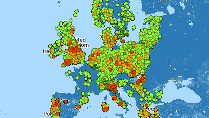
title => protected'Distribution of geogenic arsenic in European topsoil and potential concerns for food safety' (91 chars)
journal => protected'Journal of Hazardous Materials' (30 chars)
year => protected2025 (integer)
volume => protected497 (integer)
issue => protected'' (0 chars)
startpage => protected'139523 (11 pp.)' (15 chars)
otherpage => protected'' (0 chars)
categories => protected'geogenic arsenic; spatial prediction; machine learning; food safety; environ mental; hazard; soil contamination' (110 chars)
description => protected'Arsenic (As) is naturally present in trace amounts in most soils and poses a public health risk when elevated in topsoil due to potential accumulation i n agricultural products. Europe has several regions with natural As enrichme nt in soils, but since soil analyses are limited to individual soil samples, information on the spatial distribution has been lacking. This study uses e xpert-based machine learning to create a high-resolution map of As exceeding 20 mg/kg in European topsoil based on ∼4100 data points of the Geochemi cal Mapping of Agricultural and Grazing Land Soil in Europe (GEMAS) dataset and 15 environmental variables. The resulting pan-European probability map d elineates areas with high soil arsenic concentrations due to natural process es. The study finds that 11.7 % of grassland and 3.9 % of cropland in Eu rope have arsenic levels above this threshold, with France, Spain, the Weste rn Balkans, and mountain areas most affected. Commonly grown crops in these areas include wheat, maize, rapeseed, and fodder crops. Our research links e levated arsenic levels to areas with low soil water erosion. SHapley Additiv e exPlanations (SHAP) analysis was used to identify key predictors, which ma y also be relevant in other regions globally. The high-resolution As map off ers valuable insights for agricultural and health professionals and policy-m akers.' (1374 chars)
serialnumber => protected'0304-3894' (9 chars)
doi => protected'10.1016/j.jhazmat.2025.139523' (29 chars)
uid => protected35240 (integer)
_localizedUid => protected35240 (integer)modified_languageUid => protectedNULL
_versionedUid => protected35240 (integer)modifiedpid => protected124 (integer)
Mapping the chemical complexity of plastics
Plastic pollution is a pervasive and growing global problem. Chemicals in plastics are often not sufficiently considered in the overall strategy to prevent and mitigate the impacts of plastics on human health, the environment and circular economy. Here we present an inventory of 16,325 known plastic chemicals with a focus on their properties, presence in plastic and hazards. We find that diverse chemical structures serve a small set of functions, including 5,776 additives, 3,498 processing aids, 1,975 starting substances and 1,788 non-intentionally added substances. Using a hazard-based approach, we identify more than 4,200 chemicals of concern, which are persistent, bioaccumulative, mobile or toxic. We also determine 15 priority groups of chemicals, for which more than 40% of their members are of concern. Finally, we examine data gaps regarding the basic properties, hazards, uses and exposure potential of plastic chemicals. Our work maps the chemical landscape of plastics and contributes to setting the baseline for a transition towards safer and more sustainable materials and products. We propose that removing known chemicals of concern, disclosing the chemical composition and simplifying the formulation of plastics can provide pathways towards this goal.
Monclús, L.; Arp, H. P. H.; Groh, K. J.; Faltynkova, A.; Løseth, M. E.; Muncke, J.; Wang, Z.; Wolf, R.; Zimmermann, L.; Wagner, M. (2025) Mapping the chemical complexity of plastics, Nature, 643(8071), 349-355, doi:10.1038/s41586-025-09184-8, Institutional Repository
Realistic exposure scenarios in combined sewer overflows: how temporal resolution and selection of micropollutants impact risk assessment
Organic micropollutants in combined sewer overflows (CSOs) pose a potential risk to aquatic ecosystems. Previous studies mainly reported event mean concentrations (EMCs) and often focused on a small number of substances. This study presents realistic exposure scenarios using high-temporal resolution (10-minute) data from 24 events at two CSO sites. We analyzed 49 dissolved organic micropollutants for all events and 198 for four events, including pharmaceuticals, pesticides, and road-related compounds, of which we detected 83 substances at least once. From these, we assessed the mixed chemical risk by applying acute quality criteria and evaluated how the risk assessment outcome changes for two aspects: temporal resolution and selection of substances. Our results reveal that total risk quotients (RQtot) can vary greatly within CSO events, with 10-minute data capturing peak concentrations that are missed with EMCs. Using EMCs underestimates the maximum RQtot of an event by a median factor of 4.9, up to a maximum factor of 6.9. When comparing a selection of 20 substances from the Swiss Waters Protection Ordinance to a broader list of 49 substances commonly detected at CSOs and a comprehensive list of 198 substances, the estimated RQtot increases between 1.1 to 2.3-fold. RQtot values exceed the threshold of 1 in 75 % of the events, requiring further dilution in the receiving water body. All three pollutant classes (pharma, pesticide, road) drive the total risk, and no specific phase during overflow events consistently poses higher risk than other phases, which challenges the design of effective mitigation measures. Furthermore, the exposure scenarios presented here offer essential input for future ecotoxicological research as they reveal high short-term fluctuations in RQtot whose ecological significance is still largely unknown.
Furrer, V.; Junghans, M.; Singer, H.; Ort, C. (2025) Realistic exposure scenarios in combined sewer overflows: how temporal resolution and selection of micropollutants impact risk assessment, Water Research, 278, 123318 (9 pp.), doi:10.1016/j.watres.2025.123318, Institutional Repository
Distribution of geogenic arsenic in European topsoil and potential concerns for food safety
Arsenic (As) is naturally present in trace amounts in most soils and poses a public health risk when elevated in topsoil due to potential accumulation in agricultural products. Europe has several regions with natural As enrichment in soils, but since soil analyses are limited to individual soil samples, information on the spatial distribution has been lacking. This study uses expert-based machine learning to create a high-resolution map of As exceeding 20 mg/kg in European topsoil based on ∼4100 data points of the Geochemical Mapping of Agricultural and Grazing Land Soil in Europe (GEMAS) dataset and 15 environmental variables. The resulting pan-European probability map delineates areas with high soil arsenic concentrations due to natural processes. The study finds that 11.7 % of grassland and 3.9 % of cropland in Europe have arsenic levels above this threshold, with France, Spain, the Western Balkans, and mountain areas most affected. Commonly grown crops in these areas include wheat, maize, rapeseed, and fodder crops. Our research links elevated arsenic levels to areas with low soil water erosion. SHapley Additive exPlanations (SHAP) analysis was used to identify key predictors, which may also be relevant in other regions globally. The high-resolution As map offers valuable insights for agricultural and health professionals and policy-makers.
Li, K.-Y.; Covatti, G.; Podgorski, J.; Berg, M. (2025) Distribution of geogenic arsenic in European topsoil and potential concerns for food safety, Journal of Hazardous Materials, 497, 139523 (11 pp.), doi:10.1016/j.jhazmat.2025.139523, Institutional Repository
.")
.")
 and Heinz Singer in the Ms2field trailer, an automated and mobile mass spectrometer that continuously measures water quality (Photo: Eawag, Aldo Todaro).")
.")
")
")
")
")
")
")


")


")


 and nuclei (blue), Foto: Barbara Jozef")


")