Détecter et éliminer les polluants dans les cours d’eau
Pesticides, PFAS, métaux lourds, médicaments, microplastique: une multitude de substances chimiques se retrouvent dans l’environnement et polluent les cours d’eau, les lacs et les eaux souterraines. Un danger pour l'homme et la nature. L’Eawag étudie l'impact des polluants sur les êtres vivants des cours d’eau et développe des méthodes pour mieux recenser et réduire les micropolluants.
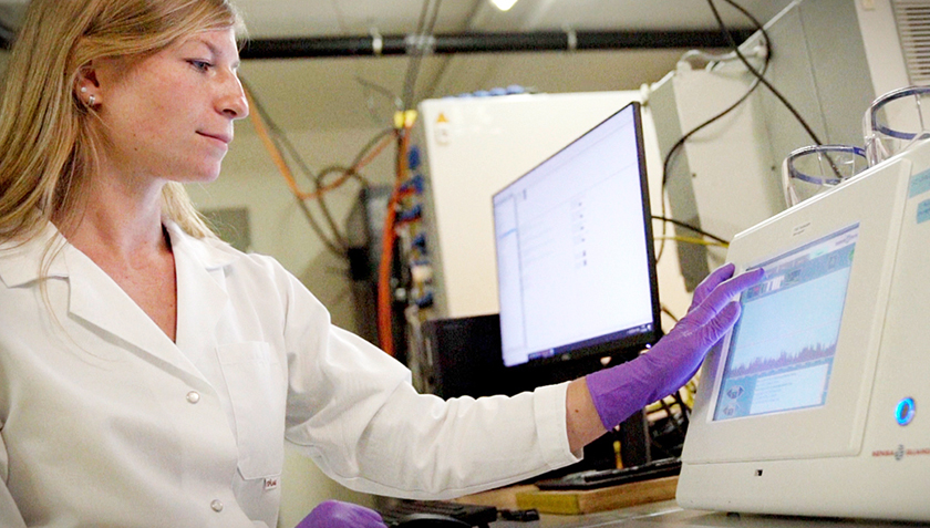
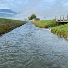
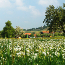
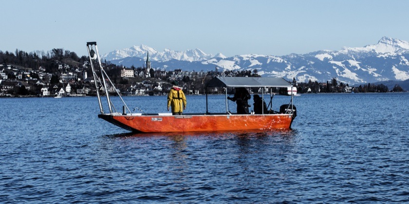
Les chercheuses et chercheurs analysent la chimie et la biologie de l’eau dans les rivières en amont et en aval des stations d’épuration (Photo: Eawag).
Un cocktail toxique pour les poissons et autres.
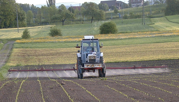
La majorité des cours d’eau suisses est chargée en micropolluants. Les pesticides et certains médicaments dépassent parfois les seuils écotoxicologiques. On détecte également des substances fabriquées par l’homme dans les eaux souterraines et les lacs. Nombre d’entre elles sont toxiques pour les êtres vivants ou perturbent leur fertilité. L’Eawag étudie l’impact des polluants sur les êtres vivants des cours d’eau et leurs effets sur les écosystèmes aquatiques de Suisse et d’autres régions du monde.
Suivre les polluants à la trace
Tous les micropolluants ne pouvaient être détectés fiablement avec les méthodes de mesure utilisées jusqu’à présent dans la pratique. Il faut pourtant déterminer aussi précisément que possible la concentration et les variations temporelles des polluants afin de pouvoir prendre des mesures concrètes de protection des eaux. C’est pourquoi l’Eawag a développé de nouveaux instruments et méthodes de mesure afin de pouvoir saisir les plus infimes concentrations de polluants, découvrir des substances jusqu’alors inconnues et déterminer les sources de ces polluants.
Christoph Ort (à gauche) et Heinz Singer dans le camion du spectomètre de masse automatisé et mobile Ms2field qui mesure en continu la qualité de l’eau (Photo: Eawag, Aldo Todaro).
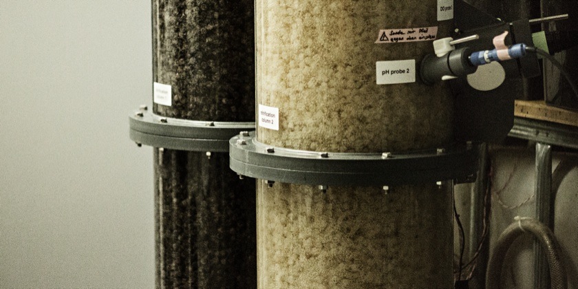
Dans son centre d’essai, l’Eawag étudie l’impact des épisodes pluvieux sur la performance du traitement des filtres au charbon actif en grains (Photo: Eawag/Alessandro Della Bella).
Réduire les micropolluants dans les eaux usées
Une partie des polluants arrive dans les cours d’eau par l’intermédiaire des eaux usées de l'industrie et des ménages. Bien que les stations d’épuration des eaux usées répondent en Suisse à un standard élevé, elles filtrent néanmoins insuffisamment ou pas du tout de nombreux produits chimiques. L’Eawag travaille au développement de nouvelles technologies qui permettront à l’avenir d’éliminer des cours d’eau ces polluants provenant des eaux usées.
Ziel dieses Projekts ist die Charakterisierung, Modellierung und Vorhersage von Enzymfamilien, die die Biotransformation von Schadstoffen in Periphyton vorantreiben.
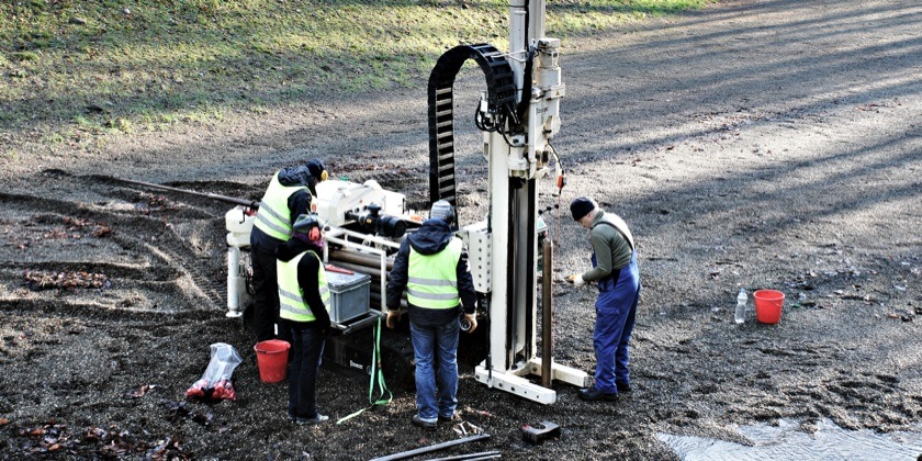
Dans le canton de Bâle-Campagne, l’état actuel de pollution et leurs risques pour les eaux souterraines ont été déterminés dans la zone modèle de Hardwald. La zone modèle est fortement urbanisée et industrialisée.
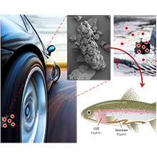
Reifen- und Straßenabriebpartikel (TRWP) entstehen durch die Erosion von Reifen während des Fahrens und machen einen großen Teil der anthropogenen Partikel aus, die in die Umwelt gelangen.
Eine grosse Zahl und Vielfalt von Chemikalien, die in Haushalten, im Gesundheitswesen, in der Industrie oder der Landwirtschaft eingesetzt werden, gelangen mit häuslichem und industriellem Abwasser in unsere Kläranlagen...
Le Centre d'écotoxicologie appliquée en Suisse a pour objectifs d'identifier et d'évaluer les effets des produits chimiques sur notre environnement et de développer des stratégies pour minimiser les risques.
array(3 items)0 => Snowflake\Publications\Domain\Model\Publicationprototypepersistent entity (uid=34990, pid=124)originalId => protected34990 (integer)
authors => protected'Monclús, L.; Arp, H. P. H.; Groh, K. J.; Falt ynkova, A.; Løseth, M. E.; Muncke, J.; Wang, Z.; W olf, R.; Zimmermann, L.; Wagner, M.' (202 chars)
title => protected'Mapping the chemical complexity of plastics' (43 chars)
journal => protected'Nature' (6 chars)
year => protected2025 (integer)
volume => protected643 (integer)
issue => protected'8071' (4 chars)
startpage => protected'349' (3 chars)
otherpage => protected'355' (3 chars)
categories => protected'' (0 chars)
description => protected'Plastic pollution is a pervasive and growing global problem. Chemicals in pl astics are often not sufficiently considered in the overall strategy to prev ent and mitigate the impacts of plastics on human health, the environment an d circular economy. Here we present an inventory of 16,325 known plastic che micals with a focus on their properties, presence in plastic and hazards. We find that diverse chemical structures serve a small set of functions, inclu ding 5,776 additives, 3,498 processing aids, 1,975 starting substances and 1 ,788 non-intentionally added substances. Using a hazard-based approach, we i dentify more than 4,200 chemicals of concern, which are persistent, bioaccum ulative, mobile or toxic. We also determine 15 priority groups of chemicals, for which more than 40% of their members are of concern. Finally, we examin e data gaps regarding the basic properties, hazards, uses and exposure poten tial of plastic chemicals. Our work maps the chemical landscape of plastics and contributes to setting the baseline for a transition towards safer and m ore sustainable materials and products. We propose that removing known chemi cals of concern, disclosing the chemical composition and simplifying the for mulation of plastics can provide pathways towards this goal.' (1276 chars)
serialnumber => protected'0028-0836' (9 chars)
doi => protected'10.1038/s41586-025-09184-8' (26 chars)
uid => protected34990 (integer)
_localizedUid => protected34990 (integer)modified_languageUid => protectedNULL
_versionedUid => protected34990 (integer)modifiedpid => protected124 (integer)1 => Snowflake\Publications\Domain\Model\Publicationprototypepersistent entity (uid=34150, pid=124)originalId => protected34150 (integer)
authors => protected'Furrer, V.; Junghans, M.; Singer, H.; Ort, C.' (65 chars)
title => protected'Realistic exposure scenarios in combined sewer overflows: how temporal resol ution and selection of micropollutants impact risk assessment' (137 chars)
journal => protected'Water Research' (14 chars)
year => protected2025 (integer)
volume => protected278 (integer)
issue => protected'' (0 chars)
startpage => protected'123318 (9 pp.)' (14 chars)
otherpage => protected'' (0 chars)
categories => protected'chemical risk assessment; acute ecotoxicity; temporal dynamics; urban draina ge; aquatic ecosystems; real exposure scenarios' (123 chars)
description => protected'Organic micropollutants in combined sewer overflows (CSOs) pose a potential risk to aquatic ecosystems. Previous studies mainly reported event mean conc entrations (EMCs) and often focused on a small number of substances. This st udy presents realistic exposure scenarios using high-temporal resolution (10 -minute) data from 24 events at two CSO sites. We analyzed 49 dissolved orga nic micropollutants for all events and 198 for four events, including pharma ceuticals, pesticides, and road-related compounds, of which we detected 83 s ubstances at least once. From these, we assessed the mixed chemical risk by applying acute quality criteria and evaluated how the risk assessment outcom e changes for two aspects: temporal resolution and selection of substances. Our results reveal that total risk quotients (RQ<sub>tot</sub>) can vary gre atly within CSO events, with 10-minute data capturing peak concentrations th at are missed with EMCs. Using EMCs underestimates the maximum RQ<sub>tot</s ub> of an event by a median factor of 4.9, up to a maximum factor of 6.9. Wh en comparing a selection of 20 substances from the Swiss Waters Protection O rdinance to a broader list of 49 substances commonly detected at CSOs and a comprehensive list of 198 substances, the estimated RQ<sub>tot</sub> increas es between 1.1 to 2.3-fold. RQ<sub>tot</sub> values exceed the threshold of 1 in 75 % of the events, requiring further dilution in the receiving water b ody. All three pollutant classes (pharma, pesticide, road) drive the total r isk, and no specific phase during overflow events consistently poses higher risk than other phases, which challenges the design of effective mitigation measures. Furthermore, the exposure scenarios presented here offer essential input for future ecotoxicological research as they reveal high short-term f luctuations in RQ<sub>tot</sub> whose ecological significance is still large ly unknown.' (1911 chars)
serialnumber => protected'0043-1354' (9 chars)
doi => protected'10.1016/j.watres.2025.123318' (28 chars)
uid => protected34150 (integer)
_localizedUid => protected34150 (integer)modified_languageUid => protectedNULL
_versionedUid => protected34150 (integer)modifiedpid => protected124 (integer)2 => Snowflake\Publications\Domain\Model\Publicationprototypepersistent entity (uid=35240, pid=124)originalId => protected35240 (integer)
authors => protected'Li, K.-Y.; Covatti, G.; Podgorski, J.; Berg, M.' (67 chars)
title => protected'Distribution of geogenic arsenic in European topsoil and potential concerns for food safety' (91 chars)
journal => protected'Journal of Hazardous Materials' (30 chars)
year => protected2025 (integer)
volume => protected497 (integer)
issue => protected'' (0 chars)
startpage => protected'139523 (11 pp.)' (15 chars)
otherpage => protected'' (0 chars)
categories => protected'geogenic arsenic; spatial prediction; machine learning; food safety; environ mental; hazard; soil contamination' (110 chars)
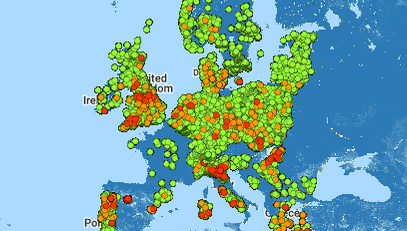
description => protected'Arsenic (As) is naturally present in trace amounts in most soils and poses a public health risk when elevated in topsoil due to potential accumulation i n agricultural products. Europe has several regions with natural As enrichme nt in soils, but since soil analyses are limited to individual soil samples, information on the spatial distribution has been lacking. This study uses e xpert-based machine learning to create a high-resolution map of As exceeding 20 mg/kg in European topsoil based on ∼4100 data points of the Geochemi cal Mapping of Agricultural and Grazing Land Soil in Europe (GEMAS) dataset and 15 environmental variables. The resulting pan-European probability map d elineates areas with high soil arsenic concentrations due to natural process es. The study finds that 11.7 % of grassland and 3.9 % of cropland in Eu rope have arsenic levels above this threshold, with France, Spain, the Weste rn Balkans, and mountain areas most affected. Commonly grown crops in these areas include wheat, maize, rapeseed, and fodder crops. Our research links e levated arsenic levels to areas with low soil water erosion. SHapley Additiv e exPlanations (SHAP) analysis was used to identify key predictors, which ma y also be relevant in other regions globally. The high-resolution As map off ers valuable insights for agricultural and health professionals and policy-m akers.' (1374 chars)
serialnumber => protected'0304-3894' (9 chars)
doi => protected'10.1016/j.jhazmat.2025.139523' (29 chars)
uid => protected35240 (integer)
_localizedUid => protected35240 (integer)modified_languageUid => protectedNULL
_versionedUid => protected35240 (integer)modifiedpid => protected124 (integer)
Mapping the chemical complexity of plastics
Plastic pollution is a pervasive and growing global problem. Chemicals in plastics are often not sufficiently considered in the overall strategy to prevent and mitigate the impacts of plastics on human health, the environment and circular economy. Here we present an inventory of 16,325 known plastic chemicals with a focus on their properties, presence in plastic and hazards. We find that diverse chemical structures serve a small set of functions, including 5,776 additives, 3,498 processing aids, 1,975 starting substances and 1,788 non-intentionally added substances. Using a hazard-based approach, we identify more than 4,200 chemicals of concern, which are persistent, bioaccumulative, mobile or toxic. We also determine 15 priority groups of chemicals, for which more than 40% of their members are of concern. Finally, we examine data gaps regarding the basic properties, hazards, uses and exposure potential of plastic chemicals. Our work maps the chemical landscape of plastics and contributes to setting the baseline for a transition towards safer and more sustainable materials and products. We propose that removing known chemicals of concern, disclosing the chemical composition and simplifying the formulation of plastics can provide pathways towards this goal.
Monclús, L.; Arp, H. P. H.; Groh, K. J.; Faltynkova, A.; Løseth, M. E.; Muncke, J.; Wang, Z.; Wolf, R.; Zimmermann, L.; Wagner, M. (2025) Mapping the chemical complexity of plastics, Nature, 643(8071), 349-355, doi:10.1038/s41586-025-09184-8, Institutional Repository
Realistic exposure scenarios in combined sewer overflows: how temporal resolution and selection of micropollutants impact risk assessment
Organic micropollutants in combined sewer overflows (CSOs) pose a potential risk to aquatic ecosystems. Previous studies mainly reported event mean concentrations (EMCs) and often focused on a small number of substances. This study presents realistic exposure scenarios using high-temporal resolution (10-minute) data from 24 events at two CSO sites. We analyzed 49 dissolved organic micropollutants for all events and 198 for four events, including pharmaceuticals, pesticides, and road-related compounds, of which we detected 83 substances at least once. From these, we assessed the mixed chemical risk by applying acute quality criteria and evaluated how the risk assessment outcome changes for two aspects: temporal resolution and selection of substances. Our results reveal that total risk quotients (RQtot) can vary greatly within CSO events, with 10-minute data capturing peak concentrations that are missed with EMCs. Using EMCs underestimates the maximum RQtot of an event by a median factor of 4.9, up to a maximum factor of 6.9. When comparing a selection of 20 substances from the Swiss Waters Protection Ordinance to a broader list of 49 substances commonly detected at CSOs and a comprehensive list of 198 substances, the estimated RQtot increases between 1.1 to 2.3-fold. RQtot values exceed the threshold of 1 in 75 % of the events, requiring further dilution in the receiving water body. All three pollutant classes (pharma, pesticide, road) drive the total risk, and no specific phase during overflow events consistently poses higher risk than other phases, which challenges the design of effective mitigation measures. Furthermore, the exposure scenarios presented here offer essential input for future ecotoxicological research as they reveal high short-term fluctuations in RQtot whose ecological significance is still largely unknown.
Furrer, V.; Junghans, M.; Singer, H.; Ort, C. (2025) Realistic exposure scenarios in combined sewer overflows: how temporal resolution and selection of micropollutants impact risk assessment, Water Research, 278, 123318 (9 pp.), doi:10.1016/j.watres.2025.123318, Institutional Repository
Distribution of geogenic arsenic in European topsoil and potential concerns for food safety
Arsenic (As) is naturally present in trace amounts in most soils and poses a public health risk when elevated in topsoil due to potential accumulation in agricultural products. Europe has several regions with natural As enrichment in soils, but since soil analyses are limited to individual soil samples, information on the spatial distribution has been lacking. This study uses expert-based machine learning to create a high-resolution map of As exceeding 20 mg/kg in European topsoil based on ∼4100 data points of the Geochemical Mapping of Agricultural and Grazing Land Soil in Europe (GEMAS) dataset and 15 environmental variables. The resulting pan-European probability map delineates areas with high soil arsenic concentrations due to natural processes. The study finds that 11.7 % of grassland and 3.9 % of cropland in Europe have arsenic levels above this threshold, with France, Spain, the Western Balkans, and mountain areas most affected. Commonly grown crops in these areas include wheat, maize, rapeseed, and fodder crops. Our research links elevated arsenic levels to areas with low soil water erosion. SHapley Additive exPlanations (SHAP) analysis was used to identify key predictors, which may also be relevant in other regions globally. The high-resolution As map offers valuable insights for agricultural and health professionals and policy-makers.
Li, K.-Y.; Covatti, G.; Podgorski, J.; Berg, M. (2025) Distribution of geogenic arsenic in European topsoil and potential concerns for food safety, Journal of Hazardous Materials, 497, 139523 (11 pp.), doi:10.1016/j.jhazmat.2025.139523, Institutional Repository
.")
.")
 et Heinz Singer dans le camion du spectomètre de masse automatisé et mobile Ms2field qui mesure en continu la qualité de l’eau (Photo: Eawag, Aldo Todaro).")
.")
")
")
")
")
")
")


")


")


 und Zellkerne (blau), Foto: Barbara Jozef")


")